
RIGS of the Month - June
Aust Cliff
Aust Cliff
Tracing an ancient drowned desert

SITE SPECIFIC INFORMATION
Location: GR = ST565895 South (downstream) of Severn Bridge.
Accessibility: Parking on B4461 Aust Wharf road at Old Passage. Via
steel gate with stile to concrete causeway. Limited access to wheelchair users.
Risks: The cliffs are dangerous.
Beware of falling rocks. Beware of the tides. Beware of mud flats.
Topography: Level estuarine foreshore beneath cliffs.
Topography: Level estuarine foreshore beneath cliffs.
All photos from this post can be viewed in a larger format -
Geological and geographical maps for Aust. Click on map for bedrock descriptions.
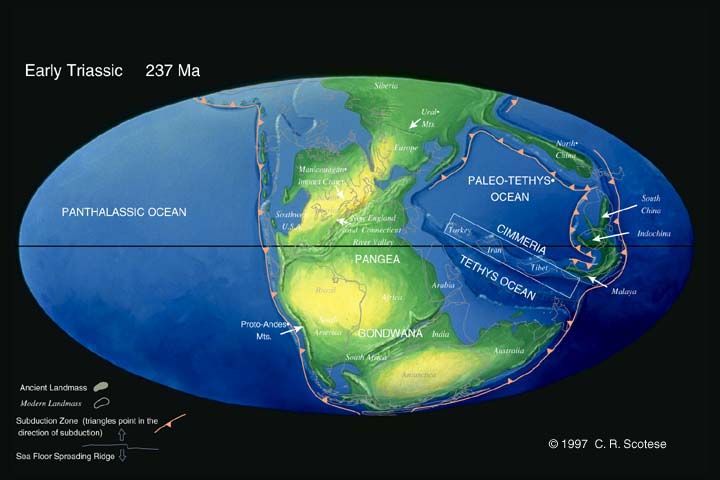
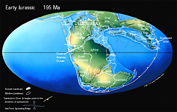
The river cliff at Aust is a
spectacular outcrop of Mid and Late Triassic to Early Jurassic sedimentary
rocks, an impressive geological archive for tracing the drowning of an ancient
hot, arid desert between ca 221
and 195million years ago.
 |
| Aust Cliff south of the River Severn Bridge. Fallen rocks on the foreshore have produced teeth of primitive sharks, remains of ichthyosaurs, pleisiosaurs and terrestrial dinosaurs. |
The succession is clearly visible
in this gently arching anticline by the striking changes of colour in the
strata. The red beds of the Mercia Mudstone Group (formerly called Keuper Marls) form the Branscombe Mudstone Formation (206 - 221 Ma) from the cliff base. These pass up to the green-grey beds
of the Blue Anchor Formation (206 – 221 Ma), (formerly called Tea Green Marls). Above the
Blue Anchor Formation rest the dark then lighter grey beds of the Penarth
Group: the Westbury Formation and Cotham Member, (formerly called Rhaetic Beds) from the Late Triassic, or
Rhaetian (206 – 210 Ma). At the cliff top are the light
brown beds of the Blue Lias Formation from the Early Jurassic, (195 – 210 Ma).
There
was extensive sedimentation in the region during the Early and Mid Triassic,
burying the older Carboniferous Black Rock Limestone landscape. This underlying
limestone platform is partly visible at low water in the curving, tilted
outcrops on the river bed upstream of the Severn Bridge, best viewed from the
pedestrian walkway. Notice also how the descending arc of the Aust Cliff
anticline and the succession upstream continues across the estuary in Sedbury
Cliff (ST555930). It is also worth noting the correlation between the
formations at Aust Cliff and those at Garden Cliff at Westbury-on-Severn, the North
Somerset and South Glamorgan coasts.
The
interpretation panel at the end of the concrete causeway to the foreshore
informs us that Aust Cliff is a Site of Special Scientific Interest and, of
course, a RIGS.
The
beds of blocky, red-brown dolomitic mudstones and siltstones of the Branscombe
Mudstone Formation are coloured by ferric oxides adsorbed onto fine-grained
sedimentary particles in well-oxygenated environments. Green-grey interbedded deposits
can also be seen in places. Well-rounded sand grains in the sediment suggest
abrasion in a wind-blown, local environment. The sediments have been deposited
in water, and the presence of evaporites (gypsum is abundant here) and celestine suggests
extensive hypersaline, enclosed, ephemeral lakes or playas.
 |
| Gypsum deposits in a long horizontal seam and vertical veins in the base of the red beds at the far end of the foreshore. Gypsum varieties: satin spar, a white fibrous form, selenite, and alabaster, a very fine-grained, white or tinted form, are present. Vertical cracks were possibly caused by folding. |
The
pale green-grey dolomitic silty mudstones and siltstones of the Blue Anchor
Formation were also formed in lakes or inter-tidal flats, depositing clays and
silts. The green colour is due to the adsorption of ferrous oxides by
sedimentary particles in a waterlogged environment. Halite (salt) pseudomorphs
have been found, indicating hypersaline conditions.
These
two formations of the Mercia Mudstone Group are devoid of macrofossils.
The
transition from the Blue Anchor Formation to the darker fossiliferous shales
and pyritised, shelly limestones of the Westbury Formation marks the change to a
stagnant, anoxic, brackish shallow sea or coastal lagoons. At the base of the
Westbury Formation is the famous Westbury Bone Bed, 15 cm thick blocks of a
conglomerate mainly of small lumps of green-grey siltstone, quartz pebbles, and
a concentration and diversity of well preserved vertebrate fragments, all
cemented into a sandy matrix.
Pieces
of the Bone Bed and the moulds and casts of bivalves can be found in rocks that
have fallen from the cliff onto the foreshore. For a list of fossil finds click here.
The
Cotham Member, named after Cotham House in Bristol, has provided specimens of
flora and fauna distinct from the Westbury Formation. These species, including
the well-known algal derived Cotham Marble from the uppermost horizon, indicate fluctuating lake levels. For native rock click here.
There
is an ongoing lively debate based on geological and geochemical evidence from
the Cotham Member in the area, and from St. Audrie’s Bay and Lavernock Point for
seismic, volcanic, meteor impact events, and their association with an end-Triassic
mass extinction.
For a
closer look at the Westbury Formation, a display of Bone Bed blocks and the
Cotham Member, visit the nearby RIGS at Manor Farm (ST576894). A detailed description of the Late Triassic strata at Manor Farm may be found in the reference below, Radley & Carpenter, 1998. There is also a good
display of Aust Cliff rock and fossil specimens in the Bristol City Museum.
 |
| Manor Farm ‘borrow pit’ was restored in 2002 and retains the Westbury Formation (bottom), Cotham Member and Blue Lias Formation (top). Despite the weathered facies there is much to see, including a good display of the Westbury Bone Bed. Private land. Enter with the owners’ permission. |
The
Aust Cliff top is mostly overgrown, but the Blue Lias interbedded limestones stacked
above the Cotham Member are visible in places. The fossil record, which
includes ammonites of Hettangian age, indicates a developed marine environment.
There is a remarkable fault in the cliff face before
the bridge footings. It helps with identifying the strata from the foreshore,
and is a final point on the trail to realise that Britain’s palaeogeography in Early to Mid Triassic Pangaea was a hot, arid desert at
latitude 30oN, North Africa today. There followed the marine
transgression in the Late Triassic and Pangaea rifted apart. In Early Jurassic Laurasia,
Britain was submerged.
 |
| A normal fault with the downthrow to the right of the fault highlighting the succession. Above the dropped green-grey Blue Anchor Formation, the darker grey Westbury Formation and light grey Cotham Member trace the marine transgression to the Blue Lias Formation brown interbedded limestones (top right). |
There
are several normal faults visible in the cliff from the foreshore, and some of
these give rise to springs. Retracing the trail, and along the concrete
causeway, a faulted section has a promontory at the base where spring water
rich in calcium carbonate is precipitating a type of limestone, forming mounds
and domes of tufa. Geological and geochemical processes are continuing today.
 |
Mounds and domes of tufa form by precipitating
calcium carbonate from spring water emerging near the cliff base.
|
John Byles
Maps
OS
Bristol & Bath Sheet 172 1:50 000 Series
References
Hamilton,
D., Aust Cliff, Geological Excursions in the Bristol District, Ed. Savage,
R.J.G., 1977.
Radley, J.D. & Carpenter, S.C., 1998, The Late Triassic Strata of Manor Farm, Aust, South Gloucestershire, Proceedings of the Bristol Naturalists' Society, 58:57-68.
Radley, J.D. & Carpenter, S.C., 1998, The Late Triassic Strata of Manor Farm, Aust, South Gloucestershire, Proceedings of the Bristol Naturalists' Society, 58:57-68.
Chidlaw. 2000. A Commentary on Geology and Scenery in the
West of England by A.E. Trueman. Allegro.
Benton,
M., Cook, E. & Turner, P., 2002, Permian and Triassic Red Beds and the
Penarth Group of Great Britain, Geological Conservation Review Series, No. 24,
Joint Nature Conservation Committee, Peterborough.
Simms,
M.J. 2007, Uniquely extensive soft-sediment deformation in the Rhaetian of the UK:
Evidence for earthquake or impact? Palaeogeography, Palaeoclimatology,
Palaeoecology 244 407–423
Gallois,
R.W. 2009, The lithostratigraphy of the Penarth Group (late Triassic) of the
Severn Estuary area. Geoscience in South-West England, 12, 71-84.
Deenen,
M.H.L. et al., 2010, A new chronology for the end-Triassic mass extinction. Earth
and Planetary Science Letters 291 113–125.
No comments:
Post a Comment